
A world deep displacement dataset, named ANDRO, after a traditional dance of Brittany meaning a swirl, comprising more than 600 000 deep displacements, has been produced from the Argo float data.
ANDRO : An Argo-based deep displacement atlas 


by M.Ollitrault (1), J.-P. Rannou (2)
(1) : IFREMER, Brest France
(2) : ALTRAN Ouest, Brest France
Data access
-
Ollitrault Michel, Rannou Philippe (2013). ANDRO: An Argo-based deep displacement dataset. SEANOE.
http://doi.org/10.17882/47077
A comprehensive processing of the Argo data collected has been done to produce a world atlas (named ANDRO for Argo New Displacements Rannou and Ollitrault) of deep displacements fully checked and corrected for possible errors found in the public Argo data files due to wrong decoding or instrument failure. The ANDRO deep velocities have been initially estimated from Argo data along the same lines and with almost the same format as Yomaha’07 atlas.
Data and Method
ASCII DEP files are generated from the Netcdf public Argo files (meta.nc, traj.nc, prof.nc and tech.nc) found on the GDAC web sites (http://www.coriolis.eu.org or http://www.usgodae.org/argo), and from all the Argos raw data provided by AOML (USA), Coriolis (France), JMA(Japan), CSIRO (Australia), BODC (UK), MEDS (Canada), INCOIS (India), CSIO (China), KORDI and KMA (Korea) DACs. Those ASCII DEP files (one file per float) are created with Argos positions, dates and location classes coming from the traj.nc files together with the real time P, T and S measurements sampled during the parking phase and the real time P, T and S values sampled during profile coming from prof.nc files. A few other measurements or data are recovered from the meta.nc and tech.nc files, and added to the DEP files.
Then, the data are checked, corrected and improved with extra information kindly provided by the DACs (float documentations, mission programming, etc…) or through a decoding of the original Argos or Iridium raw data files. Many decoder versions have been developed for this study to process raw Argo data files : 2 different decoder versions for WHOI SOLO, 3 for SIO SOLO, 23 for PROVOR and 86 for APEX. Some important processing steps can be enlightened :
- For each cycle, a realistic estimate of the float parking depth is calculated, which is very important for the use of Argo float deep displacements on tracking water motions. A new parking pressure (called RPP for Representative Park Pressure) is computed, and a systematic visual check on the RPP time-series is done to detect possible errors due to float pressure transducer ill function (mostly on APEX) or transmission error.
- For all floats which transmit cycle numbers, the Argos location dates have been checked by crossing with the theoretical cycle duration (i.e.CYCLE_TIME provided in meta.nc) to ensure the cycle number.
- Some unusable cycles have been excluded from the ANDRO atlas, like grounded cycles (that is if the float hits the sea bottom), or floats recovered at sea or after beaching, while still functioning.
Some complementary estimated data are also added, and from the final DEP files, one then generate the ANDRO atlas, which basically contains the deep displacement estimates defined as the distance between the last Argos fix and the first Argos fix of two consecutive cycles. Only Argos location classes of 1, 2 or 3 (i.e. with 1km, 350m or 150m accuracy) are used. Furthermore only those Argos positions that pass the Nakamura et al. (2008) test are preserved.
Results
The ANDRO atlas will be soon available on http://www.coriolis.eu.org/ or http://wwz.ifremer.fr/lpo/, the Coriolis or LPO sites as an ASCII file (containing 37 columns) whose format is almost identical to YoMaHa’07. The ANDRO atlas ASCII file thus contains the float parking pressure (RPP) and temperature, deep and surface displacements, and associated times, deep and surface associated velocities with their estimated errors.
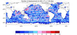
The whole Argo data collected before 1 January 2010 have been processed to generate the present ANDRO displacements. There are a total of 5 936 floats contributing 535 469 displacements (over 556 220 cycles done by a total of 5 967 floats constituting the DEP data set). Table 1 gives the ANRDO atlas displacement depth repartition. 63% of the float displacements are in the layer [900, 1100] dbar with a good (more or less uniform) coverage of all the oceans, except around Antarctica (south of 60°S). Two deeper layers, viz. [1400, 1600] dbar and [1900, 2100] dbar are also sampled (11% and 8% of the float displacements respectively) but with a poorer geographical coverage. Figure 1 gives the number of displacements within 2° by 2° boxes and for the [950, 1150] dbar interval. Although the 1000 dbar level is the most populated, two other levels (around 1500 dbar and 2000 dbar) contain useful data.
| Parking Pressure (dbar) |
Number of Displacements (5936 floats) |
|
| 0 ≤ P ≤ 250 |
16 012 |
3.0 % |
| 250 ≤ P ≤ 750 |
35 956 |
6.7 % |
| 750 ≤ P ≤ 1250 |
364 401 |
68.1 % |
| 1250 ≤ P ≤ 1750 |
61 243 |
11.4 % |
| 1750 ≤ P ≤ 2250 |
48 920 |
9.1 % |
| 2250 ≤ P ≤ 2750 |
82 |
0.0% |
| unknown |
8 855 |
1.7 % |
| Total |
535 469 |
|
Table 1 : ANDRO atlas displacement depth repartition. These displacements are estimated from the first fix of the current cycle and the last fix of the previous cycle.

ANDRO world displacement atlas for the 950-1150 dbar layer
Figure 1 : ANDRO world displacement atlas for the 950-1150 dbar layer.
As an illustration of the potential of the ANDRO atlas, Figure 2 show the mean currents over circular areas (150 km diameter) centred every degree in latitude and longitude for the Northern and Southern hemispheres, for the [950, 1150] dbar layer. Actually these mean currents are plotted as displacements over 60 days (to avoid a velocity scale). Red arrows flow eastward, blue arrows westward. Main features of the general circulation are clearly revealed strong western boundary currents, alternating jets in the equatorial region (particularly neat in the Pacific) and the strength of the Antarctic Circumpolar Current (ACC). Moreover, mean currents in the interior tend to be zonal. Mean currents were estimated with at least 30 float-days within the 150 km diameter discs.

Figure 2 : Deep displacements over 60 days near 1000 dbar for the northern (left) and southern (right) hemisphere. Eastward flow is red, westward blue.
Conclusion and Perspectives
Almost all ANDRO atlas displacement depths are in-situ measured values. YoMaHa’07 displacement depths are only copied from the meta.nc files, implying erroneous drifting depths for almost 7% of the displacements (even with perfectly filled meta files, 4% would remain, due to instrument ill function). Thanks to the Argos and Iridium raw data provided by the DACs, decoding errors have been rid of. The Argo data set has been slightly enlarged with cycles not publicly available (for unknown reason to us). Meanwhile, the DACs are progressively updating their NetCDF data files, as a result of our work. Since YoMaHa’07 atlas is regenerated periodically, the differences between ANDRO and YoMaHa’07 will tend progressively towards 4%. The ANDRO atlas (and its future updates) is freely available on Coriolis or LPO websites by 14 July 2012.
Some possible improvements on a better deep displacement estimation are planned. Actual deep displacement estimation relies only on surface locations. However, contrary to GPS locations, Argos positions are not (generally) available when the floats do surface (or dive), but slightly later (or sooner) implying possibly a few km error on the deep displacement estimated (on average there is a delay of one hour or two). To estimate the true surfacing or diving positions, one needs to determine first the corresponding times, to then extrapolate the surface float trajectory (sampled by the Argos locations) at these times. Presently, these times have been estimated for APEX floats only (for PROVORs these times are provided by the instruments themselves). The method of extrapolation developed by Park et al., 2004 has been tested on 750 floats, but with partial success. Consequently, those estimates have not been saved in the DEP files yet.
A second improvement for a better deep displacement estimates will consist in estimating the current shear between the surface and the profile depth, in order to be able, using a modeled vertical float velocity, to integrate the horizontal motion of the float during descent and ascent.
References
- Davis, R.E., Webb, D.C., Regier, L.A. and J. Dufour : The autonomous Lagrangian circulation explorer (ALACE). J. Atmos. Ocean. Technol., 9, 264-285, 1992
- Davis, R.E. : Intermediate-depth circulation of the Indian and south Pacific Oceans measured by autonomous floats. J. Phys. Oceanogr., 35, 683-707, 2005.
- Lebedev, K.V., Yoshinari, H., Maximenko, N.A. and P.W. Hacker : YoMaHa’07-Velocity data assessed from trajectories of Argo floats at parking level and at the sea surface. IPRC Tech. Note n°4(2), 2007.
- Nakamura, T., Ogita, N. and T. Kobayashi : Quality control method of Argo float position data. JAMSTEC Report Res. and Dev., 7, 11-18, 2008.
- Ollitrault, M., Loaëc, G. and C. Dumortier : MARVOR: a multi-cycle RAFOS float. Sea Technology, 35, n°2, 39-44, 1994.
- Ollitrault, M., Lankhorst, M., Fratantoni, D., Richardson P. and W. Zenk : Zonal intermediate currents in the equatorial Atlantic Ocean. Geophys. Res. Letters, 33, L05605, doi:10.1029/2005GL025368, 2006.
- Ollitrault M., J.-P. Rannou : ANDRO, An Argo-based deep displacement atlas, JAOT, submitted, 2012
- Park, J.J., Kim, K. and W.R. Crawford : Inertial currents estimated from surface trajectories of Argo floats. Geophys. Res. Letters, 31, L13307, doi:10.1029/2004GL020191, 2004.
- Park, J.J., Kim, K., King, B.A. and Riser, S.C. : An advanced method to estimate deep currents from profiling floats. J. Atmos. and Ocean. Technol., 22, 1294-1304, 2005.
- Rossby, T. and D. Webb : Observing abyssal motion by tracking Swallow floats in the SOFAR channel. Deep-Sea Res., 17, 359-365, 1970.
- Rossby, T., Dorson, D. and J. Fontaine : The RAFOS system. J. Atmos. Ocean. Technol., 3, 672-679, 1986.
- Swallow, J.C. : A neutral-buoyancy float for measuring deep currents. Deep-Sea Res., 3, 74-81, 1955.
- Wunsch, C.: The past and future Ocean circulation from a contemporary perspective. AGU Geophysical Monograph n°173, 53-74, 2008.
- Yoshinari, H., Maximenko, N.A. and P.W. Hacker : YoMaHa’05-Velocity data assessed from trajectories of Argo floats at parking level and at the sea surface. IPRC Tech. Note n°4, 2006.