
Supported by the GMMC in 2010, the SECARGO project has enabled the ARGO / Coriolis network development, and the collection of new CTDs / XBTs measurements in a region far from sparse in situ observations. The entire network of measurements in the Southwest Pacific Ocean is thus expanding gradually, and allows for a better regional understanding of the circulation. In particular, recent results from Gasparin et al. (2011 and 2012) provide new investigative ways for the study of the dynamics of the Coral Sea.
Contribution to the ARGO/CORIOLIS network in the Coral Sea
by Christophe Maes *(a)
(*) : Corresponding author Christophe.Maes@ird.fr
(a) : IRD/LEGOS, Toulouse
The Southwest Pacific region plays an essential role in the global climate variability as it is the crossroads between the equatorial band, whose interannual variability is the strongest in the world, El Niño / Southern Oscillation events and the subtropical circulation. Locally, the variability of the Southwest Pacific also generates regional climate feedbacks whose tsocio-economic and environmental impacts are significant for the entire population of the various states and island nations that compose it.
Yet this vast oceanic region remains poorly observed and the physical mechanisms that govern it are also poorly understood. Integrated to the SPICE (Southwest Pacific Ocean Circulation and Climate Experiment) program, itself supported by WCRP and CLIVAR international programs on climate studies, the SECARGO project focuses on the dynamics of ocean circulation in the Coral Sea and Solomon Sea. In particular, the Coral Sea is a semi-enclosed sea and dotted with numerous islands and reefs scattered around in it, which is not more than a few tens of kilometers but where ocean dynamics is complex.
Supported by the GMMC in 2010, the SECARGO project has enabled the ARGO / Coriolis network development, and the collection of new CTDs / XBTs measurements in a region far from sparse in situ observations. The entire network of measurements in the Southwest Pacific Ocean is thus expanding gradually, and allows for a better regional understanding of the circulation. In particular, recent results from Gasparin et al. (2011 and 2012) provide new investigative ways for the study of the dynamics of the Coral Sea.
Scientific Interest
The SECARGO project was implemented in 2010 in the framework of SPICE program (Ganachaud et al., 2007), which brings together since 2008 research efforts of American States, French, Australian, New Zealand and other island countries in the study of the thermocline waters contribution in the Coral Sea and the study of the hydrological characteristics of the Coral Sea and Solomon Sea.
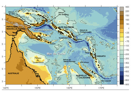
Figure 1 : Geography and topography at the bottom of the SouthWest Pacific Ocean (from Gasparin, 2012)
Waters of the South Pacific subtropical gyre are mainly transported westward by the South Equatorial Current (SEC) between 4°N and 30°S. The main part of ocean waters between the surface and 1000m depth returning in the Coral Sea come from French Polynesia and are transported by the SEC. In deed, initially large and mainly zonal, the SEC splits into several jets and western boundary currents to meet the islands of Fiji, Vanuatu, New Caledonia and the Australian coasts. The first maps of Argo float trajectories in this region clearly show their entry into the Coral Sea between 10°S and 20°S, through two zonal jets: the North Caledonian Jet (NCJ, 18° S-16°S, north of the d'Entrecasteaux reef) and the North Vanuatu Jet (NVJ, 14°S-11°S, north of the archipelago of Vanuatu).
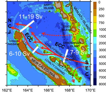
Figure 2 : Topography, main water pathways and estimated transports from Gasparin et al., 2011.
SEC = South Equatorial Current; ECC = East Caledonian Current; NCJ = North Caledonian Jet
Observed and first described during the IRD oceanographic campaigns in 2004-2005 and in a section covered by a glider across the Coral Sea from the island of Guadalcanal until Bourail, the North Caledonian Jet would be the most intense and narrower jet of the circulation in the Coral Sea. The SECARGO project aims to complete the description of this jet in order to document its vertical extension, its total mass transport, its core characteristics and the physical properties of waters it carries.
More generally, the SECARGO project aims to provide elements to understand the influence of North Caledonian Jet on long-term fluctuations of the equatorial waters fed by the SEC, and thereby on the El Niño variability.
Data and Methodology
After some first actions in 2004 for the establishment of a network of observations in the Coral Sea and the deployments of twenty PROVOR during the FRONTALIS-3 campaign in 2005 and two APEX during the FLUSEC-01 campaign in 2007 the SECARGO project completed this network off New Caledonia by collecting new Argo, CTDs and XBTs profiles. Conducted in May 2010 aboard the R/V Alis, the SECARGO campaign allowed the deployment of four APEX floats. Subsequently, five APEX were also deployed in the same region as well as two PROVOR-DO floats equipped with oxygen sensors, a primary action for this region.
In parallel with the Argo network, two sections between Nouméa and Honiara realized from merchant ships with XBTs probes provided by SHOM and IFREMER complemented these in situ observations since 2008 (Maes et al., 2011). Argo data are compared with CTDs profiles made at the deployment, and comparisons are made with climatological data from the CARS climatology 2009 from Ridgway et al., 2002.
The entire in-situ observations network is schematized in Figure 3 herebelow.
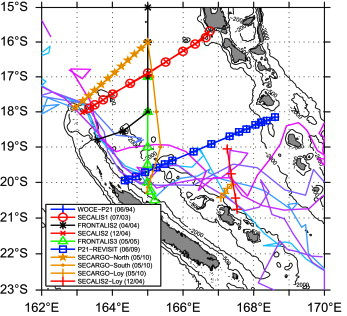
Figure 3 : Hydrological station positions and Argo floats trajectories at 1000 m in the region of interest. Markers joined by lines indicate hydrological stations for each cruise (legend). Argo trajectories are indicated by the blue-purple curves. For best visibility, only Argo floats having a continuous trajectory along the SEC-ECC-NCJ pathways are shown. Fine continuous lines indicate the 500 m and 2000 m depth of the topography. The cruise trajectories are neither strictly straight nor perpendicular to the coast, and to facilitate comparisons we defined, in the following, a common axis which represents the distance perpendicular to the tilted east coast of NC.
Preliminary Results
The combined analysis of the first in situ data helped establish the characteristics of the western boundary current east of the New Caledonia coast. This current measuring about 100 km wide, is located between 10 to 100 km from the coast and at a depth greater than 1000m. It carries about a third of the mass transport between New Caledonia and Vanuatu, the maximum of 19 Sv was estimated during the SECARGO campaign in May 2010.
Within SECARGO, comparisons between ARGO profiles and CTDs (Fig. 4) or climatological (Fig. 5) profiles showed no anomaly concerning the ARGO measurements. A delayed-mode quality control on these data is being finalized and the first results show reliable instruments and data robust enough to be exploited scientifically.
To further develop the Argo / Coriolis network in this region of the SouthWest Pacific, actions were carried out in 2011 (one PROVOR oxygen float deployed) and 2012 (five ARVOR and PROVOR with optode floats deployed between 16°40' S and 12°S along 163°E in the Coral Sea ; two additional ARVOR floats) as part of the BIFURCATION campaign or SPRAYALIS-3 oceanographic campaign.
The thesis recently supported at the University Paul Sabatier (Toulouse III) by Florent Gasparin in 2012 proposed a documentation of the ocean circulation and characteristics of water masses around these jets using hydrological data from oceanographic cruises for the 1993-2010 period. It provides a better understanding of the Southwest Pacific region and provides new investigative ways for the study of the dynamics of the Coral Sea. Efforts to develop and maintain a network of observations in the Southwest Pacific Ocean promise a better understanding of the variability of the ocean circulation in a key area for the global earth climate balance.
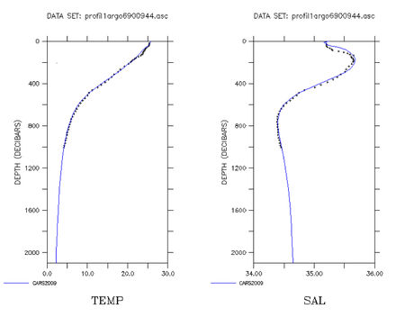
Figure 4 : Temperature (on left) and salinity (on right) profiles function of pressure from Argo float #wmo 6900944
compared with colocated climatological profile from CARS 2009 climatology
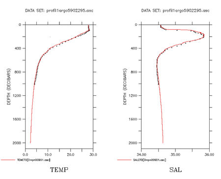
Figure 5 : Temperature (left) and salinity (right) profiles function of pressure from Argo float #wmo 5902295
compared with colocated CTD profile realized at time of the deployment
Interesting Links
SPICE project : http://spice.legos.obs-mip.fr/
CLImate VARiability and predictability (CLIVAR) program : http://www.clivar.org
World Climate Research Program (WRCP) : http://www.wcrp-climate.org/
Climatology CARS 2009 : http://www.marine.csiro.au/~dunn/cars2009/
IMOS project : http://imos.aodn.org.au/imos/
References
- Ganachaud, A., G. Brassington, W. Kessler, C.R. Mechoso, S. Wijffels, K. Ridgway, W. Cai, N. Holbrook, P. Sutton, M. Bowen, B. Qiu, A. Timmermann, D. Roemmich, J. Sprintall, D. Neelin, B. Lintner, H. Diamond, S. Cravatte, L. Gourdeau, P. Eastwood, and T. Aung, 2008 : Southwest Pacific Ocean Circulation and Climate Experiment—Part II. Implementation plan. International CLIVAR Project Office, CLIVAR Publication Series No. 133, NOAA OAR Special Report, 36 pp.
- Gasparin, F., A. Ganachaud, and C. Maes, A western boundary current east of New Caledonia: observed characteristics, Deep Sea Res. I, 58, 956-969, 2011
- Gasparin F, 2012 : Etude des caractéristiques des masses d’eaux, du transport de masse et de la variabilité de la circulation océanique en Mer de Corail. Thèse de doctorat de l’Université Paul Sabatier, Toulouse.
- Gasparin, F., Ganachaud, A., Maes, C., Marin, F., Eldin, G., 2012. Oceanic transports through the Solomon Sea: The bend of the New Guinea Coastal Undercurrent. Geophysical Research Letters 39. 10.1029/2012GL052575
- Maes, C., L. Gourdeau, X. Couvelard, and A. Ganachaud, What are the origins of the Antarctic Intermediate Waters transported by the North Caledonian Jet, Geophys. Res. Let., 34, L21608, doi:10.1029/2007GL031546, 2007
- Maes C. et al., 2011 : Geostrophic component of oceanic jets entering in the eastern Coral Sea as observed with high-resolution XBT surveys (2008-2010). Coriolis Mercator Ocean Quaterly Newsletter, 41, 25-32.
- Ridgway K.R., J.R. Dunn, and J.L. Wilkin, 2002 : Ocean interpolation by four-dimensional least squares -Application to the waters around Australia, J. Atmos. Ocean. Tech., Vol 19, No 9, 1357-1375.